New “Lizard Map” an invitation to adventure
There’s no reading material like a map. A map can guide you from points A to B, for sure, but a map can be so much more, especially outdoors. A map can be a ticket to relive fishing, hunting or exploring memories that might otherwise fade. Or, maps can present the allure of new adventure not yet savored, but within your grasp because you can envision it reading a map.
I’m of a generation that still likes maps made of paper, and substantial paper is that much better. I know digital maps have outpaced printed ones in popularity, but I like the reassuring ritual of checking a map in the woods, then folding it up to tuck in a pack or shirt pocket. I can sense its presence and know it’s there. No battery failure, satellite-blocking overcast, or dousing rain can knock it “off-line.” Handled with appropriate care, a printed map is both durable and indispensable, like a good and trusted knife.
Recently, I acquired a new map which, despite my acknowledged “maturity,” I can best describe as “cool.” It’s the most detailed, informative, and stimulating map of our region I’ve ever perused. Best of all, it beckons you to venture out to new places and try new things.
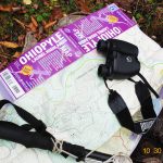
It’s the Lizard Map of Ohiopyle and the Laurel Highlands, available from Mountain Watershed Association, the non-profit but highly active organization that promotes and protects the Laurel Highlands’ rivers and streams. For long spans of enjoyable scanning, I’ve never seen a map like it.
The Lizard Map folds out to about 3 feet by 2 feet, printed on durable water-resistant stock. On one side is the entire Laurel Highlands region, from Smithton and the Flight 93 National Memorial in the northwest and northeast corners, to the Mason-Dixon Line–roughly from Quebec Wild Area eastward to the Big Savage Tunnel on the Great Allegheny Passage northwest of Cumberland, Maryland. That’s about 875 square miles in which Uniontown and its suburbs are the largest urbanized place.
The map’s “flip-side” zeroes in on Ohiopyle, increasingly an acknowledged outdoor destination for much of the nation. One-hundred forty square miles are portrayed, from Youghiogheny Reservoir northwest to remote stretches of the “Dunbar Mountains” within State Game Land No. 51. Ohiopyle State Park and the Youghiogheny Gorge dominate the center.
For an outdoor user, both sides highlight public land, like state parks, state forests, game lands and National Park sites in distinctly keyed colors. Trails and their access points for hiking, biking or paddling (river trails) are conspicuously marked. Parking areas, campsites, picnic areas, ranger stations, as well as prohibited “no camping” areas are clearly shown.
But almost any map provides such basic requirements. What makes the Lizard Map of Ohiopyle and the Laurel Highlands unique and “cool” are the additional touches you don’t expect on such a utilitarian tool as a map. Scattered across both sides are interpretive boxes that explain our region’s internationally significant history and geography–like this quote from George Washington’s journal: “May 20, 1754…We gained Turkey-foot by the beginning of the night…The 21st tarried there some time to examine the place. We went down the river about 10 miles when at last it became so rapid as to oblige us to come ashore.” Washington is writing, of course, about the Youghiogheny downstream from Confluence, described to him by Indians as a place where three rivers (Youghiogheny, Casselman and Laurel Hill) come together, resembling a turkey’s foot.
There’s even inspiration and insight sprinkled across the Lizard Map’s surface, including a quote from Ernest Hemingway: “It is by riding a bicycle that you learn the contours of a country best, since you have to sweat up the hills and coast down them.”
Readers may be wondering why it’s called the Lizard Map. We do have true lizards in our region, but they’re uncommon, secretive and difficult to find. Tiny lizard symbols explain the name. The symbols indicate places of special interest. “This could mean anything,” states the map legend, “a cool place, sweet view or a local legend.”
As an example, a lizard symbol marks a grid of old stone walls that once marked the boundaries of a farm along the Youghiogheny above Ohiopyle. Today the walls course through forest, but they testify to the hard work and determination of settlers who, for a time, wrested a living out of a mountain gorge.
My Lizard Map hasn’t hit the woods yet, but it makes great bedtime reading. I like to scan the contours and pick out places where I’ve called in a turkey, killed a grouse, or swamped a canoe. Even better, it lures me to hike a new path or fish a new stream.
The people who publish Lizard Maps don’t make them for just anyplace. They pick locations around North America with outstanding natural features and outdoor options. Ohiopyle and the Laurel Highlands made the grade. You can get a copy of the Lizard Map from the Mountain Watershed Association at www.mtwatershed.com.
Ben Moyer is a member of the Pennsylvania Outdoor Writers Association and the Outdoor Writers Association of America.