Late for Laurel
Mountain laurel’s peak bloom is past, but view is worth planning a year ahead
 Ben Moyer
To best serve readers, this column should have been written two weeks ago. Good things change fast in the outdoors and a writer always needs to look ahead.
Please excuse this tardy alert and consider it an early heads-up for June 2026.
Around here, we often tout the Laurel Highlands. And we should. It is a beautiful region of diverse natural and cultural features with much to offer residents and visitors alike. We even have a high school with that name, from which I proudly graduated many years ago. Several businesses claim the title, as does our regional tourism agency, and the Laurel Highlands Hiking Trail courses 70 miles from Ohiopyle to Johnstown.
But how often are we reminded of where that name originates? How many of us have, or make, the opportunity to savor this region’s most acclaimed symbol?
That symbol, from which the Laurel Highlands take their esteemed name, is the mountain laurel, a mid-size shrub that is not widely common, but grows in profusion in the right kind of places, which are rocky, high-elevation sites with adequate sunshine and well-drained soils.
For 49 of the year’s 52 weeks, you might not notice mountain laurel if you drove or walked past it. Its leathery green leaves blend with its forest surroundings. But from the first through the third weeks of June, mountain laurel’s flowers erupt in an excess of bloom that merits more attention. The plant got that attention in 1933 when Governor Gifford Pinchot proclaimed it Pennsylvania’s official state flower, but except for its promotional name-power seems forgotten ever since.
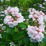
Mountain laurel flowers range from white to deep-pink. But it’s the plant’s form that makes it so stunning to the eye. The flowers occur in globular bundles (known to botanists as a corymb) about the size of a softball. These bundles are tightly packed over the entire surface of the shrub, so that in full bloom the plant looks like it’s mantled in pink snow. In places where laurel shrubs cover acres of mountain land, the total effect is, literally, breathtaking.
Everyone who enjoys nature deserves to be introduced to mountain laurel, but it’s too late to make its acquaintance this year. By the time this appears in print, laurel will be past its peak bloom.
That’s why this column should have been written two weeks ago.
But it’s an apt time to plan for June 2026, when mountain laurel will again blaze the highlands.
If you’re an adventurous hiker, you’ll find mountain laurel blooming in mid-June along miles of secluded mountain trails all over the region — the higher and more remote the better. Those adventurous folks like to find their own rewards. But more casual visitors to the mountains should enjoy mountain laurel too. Below are some suggestions for places to see Pennsylvania’s state flower at its best next June.
Skyline Drive
State Route 2001, also known as Skyline Drive, heading south from Rte. 40 at the Summit passes through Forbes State Forest and State Game Lands 138 on the way to what, hopefully, will soon be our newest state park — Laurel Caverns. Mountain laurel blooms along both sides of the road. Safe parking is available on the state forest and on the game lands, so you can examine mountain laurel up close, take a walk, and get photos if you like.
Jumonville Road
State Route 2021, Jumonville Road, tracks the spine of Chestnut Ridge north of Rte. 40 at the Summit. This year mountain laurel bloomed in profusion there. Note, however, that all the blooming sites north of Rte. 40 are on private property. Take in the beauty from your car window here. Always remember that the intersections heading south from Rte. 40 on Skyline Drive and north on Jumonville Road are dangerous spots. Too many drivers crest the mountain at high speed. Use those junctures with extreme caution or access from another way. You can get to Skyline Drive from Mud Pike in Georges Township, and Jumonville Road can be reached from Coolspring and Rte. 119 in North Union Township.
Mt. Davis
An ideal location for viewing mountain laurel from the comfort of your car, or on a short and easy hike, is Mt. Davis Natural Area and the surrounding Forbes State Forest in Somerset County.
At 3,213 feet in elevation, Mt. Davis is Pennsylvania’s highest point above sea level, and mountain laurel likes it there. Any of the state forest roads around Mt. Davis will yield stunning views. Some of the best laurel-peeping is along Vought Rock Road, headed north from Mt. Davis Road just a few hundred yards east of the sign for the Mt. Davis observation tower. You don’t have to go far. Head north on Vought Rock Road for one mile north of Mt. Davis Road and you’ve seen the best. Turn around at the four-way dirt road intersection. If you go beyond there, let me know where you eventually find yourself.
Mt. Davis is about 45 minutes to an hour east of Uniontown. Follow Rte. 40 east across Youghiogheny Reservoir to Rte. 523 North. Head north on Rte. 523 to Listonburg, then turn right (east) on Mt. Davis Road (SR 2004). Continue east past High Point and Deer Valley lakes to Mt. Davis.
If you go there next June, all of Pennsylvania’s 13 million people will stand below you, and you’ll know why you’re in the Laurel Highlands. It’s the laurel — mountain laurel.